
How LiDAR Brings Spatial Intelligence To Airports
The performance and price of LiDARs, an important technology that can offer unique insights, have dramatically improved in the last few years.
The emergence of new software applications, such as Outsight’s, is making it possible for non-Lidar specialists to easily and quickly make use of LiDAR technology.
This article will explore how and why airports are making good use of LiDAR-based solutions to take maximum advantage of this amazing technology.
By Raul Bravo, President, Outsight.
The growing difficulties airports, airlines, and travellers are encountering are all too familiar to anyone who frequently travels. We are experiencing a surge in airline delays and cancellations, congested TSA lines, and misplaced luggage as thousands of travellers flock to the airport to make up for missed travels after the pandemic.
Additionally, airports continue to experience staffing problems, such as a shortage of baggage handlers, which when coupled with the spike in demand for travel has resulted in even more lost bags; consumer complaints about airlines have reached historically high levels as a result of all these problems.
Airports are complex places. They need to be safe, able to handle a wide variety of users, and offer travellers quick and easy access, while controlling traffic in an area that is increasingly constrained.
Airports operators are responding by introducing new technologies to simplify procedures and improve the traveller experience.
This article explores how and why they are increasingly using LiDAR-based Software solutions to tackle these challenges, leveraging the unique value of Spatial Intelligence.
Why LidAR?
Many people first learned about the value of LiDAR data thanks to the Self-Driving Car application, which will be widely deployed at scale sooner or (more likely) later.
Unlike existing 2D-based perception technologies such as cameras, the 3D data from LiDAR produces highly detailed, accurate spatial measurements and works in a range of environments and contexts, such as during the night and under direct sunlight.
In order to determine the distance, shape, and velocity of objects, the sensor illuminates the surrounding area with millions of low-power laser light spots that are invisible to the human eye and measures how long it takes for the light to reflect back. That is what its name, LIght Detection And Ranging, actually means.
This new kind of sensor also offers an important nontechnical advantage: no personally identifiable information is ever captured.

The technology has recently attracted a lot of attention since it can make anything that moves, monitors moving things, or involves measuring volumes smarter, more effective and safer. That's a big market.
In fact, several billion dollars have been spent on the development of LiDAR hardware technology and approximately 100 businesses manufacture LiDARs. About 10 of them have went public.
Why now?
As a direct consequence of this fierce competition and ample resources in the hardware development, three consequences have emerged, each of which is of particular relevance to airports:
1. In a few years, performance has greatly improved and price has dramatically decreased, making it competitive against legacy 2D sensing solutions in most market segments. This is especially relevant for airports when one considers the total number of units, installation and processing costs that are required to monitor a certain area.

2. Given the long-term and low cost nature of the automotive business and the even longer-term deployment of self-driving cars at scale, the industry is increasingly focusing on applications in all other areas and developing solutions that are specifically tailored to them.
This includes Mobile Robotics, Industrial applications as well as Infrastructure such as Airports.
For example, a new kind of sensor of type “Dome” has been designed for low-ceiling situations typically found in passport control zones or inter-terminal aisles.

3. The emergence of a wide variety of applications, contexts, and markets has shifted the focus of technological development from commoditized hardware toward the development of Software solutions that make it possible for non-LiDAR specialists to make use of this technology in the quickest and easiest way.
Indeed, LiDAR hardware only provides raw data that can't be used “as is” without the appropriate software.
Companies like Outsight has created a new category of LiDAR Software adapted to the new evolution stage of the market: an Edge LiDAR Software Pre-Processor receives a heterogeneous set of data from different manufacturers and types as an input, processes it in real-time, and delivers a standardized stream of actionable information.

Thanks to software an amazing technology like LiDAR can show its full potential and become ubiquitous, and its benefits accessible to all.
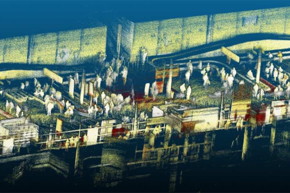
See this example at a luggage claim zone where thousands of travellers, luggage and trolleys are anonymously tracked:

Software enables this extraordinary LiDAR technology to reach their full potential, become commonplace, and make their benefits available to all.
Achieving Operational Excellence
As we have seen, now the Hardware is affordable and performant, it is well-tuned for infrastructure applications like airports, and the Software necessary to make it functional has finally been developed.
So how is the technology being used in Airports?
Even if Security is of course an important use of the technology, LiDAR is being deployed in priority in operations with the objective of increasing Operational excellence.
Lidar technology can enhance many aspects of airport operations: they present a complex ecosystem where this precise technology can bring great value for safety and efficiency, from terminal facilities with crowd monitoring and baggage transport to equipment and cargo movement to aircraft traffic and maintenance.
The information gathered can be applied to different objectives:

Only in a Luggage Claim zone you can find many concrete use cases:

In a Passport Control zone, the precise tracking of each individual allows streamlining the process and allocating the right resources at the right time:

LiDAR and Software can track people and objects, but this is insufficient to make this technology effective to meet the objectives of the different use cases.
The market requires solutions that also fit the following four requirements:
1. Monitoring wide areas thanks to multi-LiDAR Fusion
Monitoring a wide area of many square meters, in different levels, from Parking to Departures and Arrivals, requires much more than a sensor and object tracking software.
Instead, a comprehensive solution that enables the smooth integration of dozens to hundreds of sensors must be used.

The technical challenge is not small, including managing the precise position, orientation, and timing of each individual LiDAR, simultaneously, is crucial for the ensuing performance.
The strain on the local network caused by processing millions of points per second can only be handled by the best edge processing software. This will become increasingly important when sensor resolution grows; during the next 18 months, some manufacturers may provide sensors with a fivefold improvement in resolution.
The benefits, on the other hand, are significant. Thanks to the Spatial Intelligence provided by LiDAR-based software solutions like the one offered by Outsight, you are now able to ask significantly more pertinent questions:

2. Instantaneous and Aggregated KPI data
Airport LiDAR Solutions like Outsight's don't stop at object tracking, but deliver an actionable Dashboard, where the right KPI's can be set by the users, easily accessible from any web browser.

The Dashboard must give both in-the-moment warnings and cumulative data over time, with the option to delve into historical data to better understand events and trends, in order to be comprehensive and valuable.

To give you an idea of scale, the Outsight solution installed in airports like Charles-de-Gaulle Airport in Paris has already accumulated 3.8 billion anonymous data points, which are easily available to authorized operators.
3. Scalable and future-proof
As we've seen, the LiDAR hardware industry is quite diverse and dynamic. Different sensors and manufacturers have strengths and disadvantages in particular areas, without even mentioning the various price schemes, leaving no universally applicable solution.

Short-range sensors, typically working at 905 nm wavelengths are better for constrained spaces, as they optimize resolution, while Long Range ones, typically at 1550 nm are great for covering long distances, especially helpful in the Tarmac and for perimeter security purposes.
Airport operators must be certain that the proper sensor is being used for the right application, eventually procuring multiple sources of equivalent brands for the same purpose for supply-chain security.
Accordingly, employing, integrating, and combining various sensors from different manufacturers is essential for both immediate and long-term success.
An international airport operator who is one of Outsight's clients, as an illustration, deployed a first site with a particular manufacturer. Because of the distinct physical architecture and constraints, a combination of gear from two separate manufacturers was used to deploy the second site.
The first two sites consequently needed three distinct hardware sensors. Eventually, more sites might need different ones.
4. Managing the whole project lifecycle
Due to the complexity of integrating 3D LiDAR to obtain Spatial Intelligence, Airports must rely on purpose-built comprehensive solutions that span the entire project lifecycle.
This starts with a 3D planification through the appropriate simulation tools, in order to understand the best solution to be used.

As the project evolves and the solution is increasingly interconnected to other airport systems, only open API solutions with standard protocols can guarantee the required flexibility.

Conclusion
Airports are leading the way among all applications in Smart Infrastructure when it comes to the implementation of large-scale LiDAR-based solutions.
This has been made possible by the introduction of Lidar-agnostic comprehensive software solutions like those offered by Outsight, as well as by the correct timing of the hardware market with prices continuing to fall.
The unique insight that can only be obtained from 3D data, when processed with the right software, provides a level of Spatial Intelligence that was not previously obtainable by traditional 2D sensors such as cameras, fostering airport Operational Excellence and Security.

The leading global integrated photonics conference and exhibition will once again bring together key players from across the value chain for two-days of strategic technical sessions, dynamic talks and unrivalled networking opportunities.
Join us face-to-face on 28th – 29th June 2022
- View the agenda.
- 3 for the price of 1. Register your place and gain complementary access to TWO FURTHER industry leading conferences: CS International and PIC International.
- Email info@sensorsinternational.net or call +44 (0)24 7671 8970 for more details.
*90% of exhibition space has gone - book your booth before it’s too late!


